Classification : Geosite of World UNESCO Geopark
Managing Organization : Municipality of Jaunac and Community of Municipalities of Val’Eyrieux
Presentation :
The Brion rock is a volcanic formation, geologically attached to the province of eastern Velay, and more specifically to the Mézenc-Gerbier Massif. Around 10 million years ago, the uplift of the Alps reactivated a number of fractures and dislocations, and favored the development of volcanic activity in the Massif Central : the Brion rock constitutes one of its eastern extremities. Fluid lava at a temperature of around 1,200°C took advantage of a fracture in the granite rocks to reach the surface, solidifying in the duct through which it passed : it is called the “dyke”.
From the Messinian crisis, the digging of the valleys in the Boutières eroded the reliefs, and, according to the degree of resistance of the rocks, caused a phenomenon of reversal of reliefs : the volcanic rocks, harder, were found put relief supply lines for volcanism, such as the Brion dyke, have been gradually removed. The erosion has stripped the prisms from the cooling of the lava. Oriented NO / SE, the dyke forms a “wall” which measures approximately 500m in length. The organs that compose it are of quite varied inclinations; on the other hand, it should be noted that on the eastern part of the site, all the organs are vertical, which suggests the formation of a sub-horizontal vein: a sill.
A flow is located to the west of the site, a little downstream of the dyke. It forms a mountain ridge in inversion of relief compared to the paleo-valley in which it was poured out. The link between the dyke and this flow is not proven, because the composition of the rock differs : the basalt of Brion rock is rich in small crystals of olivine and pyroxene phenocrysts, from centimeter to pluricentric size. On the other hand, the latter are almost absent from casting, which has more olivine crystals and peridotite enclaves.
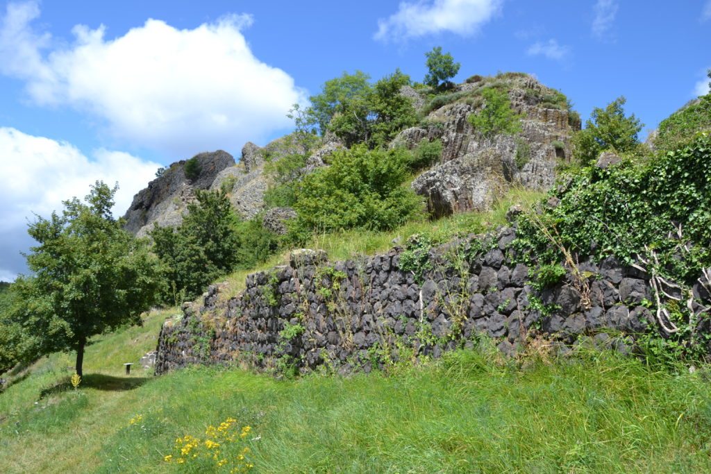
The episodes of Quaternary glaciations are at the origin of the scree which surrounds the rock : large blocks of prisms are detached from the walls, fell, and stabilized below. These slopes are now covered by vegetation. The gradual erosion of the dike at the top has formed a flat area on which dwellings have been found, dating for the oldest, from the 12th century.
Ruins of the castle and the village of Brion are visible on the site. Archaeological excavations have unveiled in particular vestiges dating from the 13th and 17th centuries : dwellings, but also the spectacular ancient rampart that surrounded the village, fossil terraces, etc. The buildings are constructed from volcanic organs from a quarry on the site.
A particular flora has developed on the site, due to human occupation for centuries. We thus find plants from ancient forage crops or plants that grow specifically on ruins. Certain varieties are more specifically linked to the basaltic nature of the soil : permanent leaching promotes the growth of male dogwood, for example.
Scientific or educational interests :
A joint study of the site was carried out by a geomorphologist, a botanist, an archaeologist and a historian. The overall cohesion of the project made it possible to carry out archaeological excavations on three occasions between 1999 and 2002, then a doctoral student in archeology more recently carried out excavations.
The site of the Rocher de Brion presents a great diversity in the objects of study : organs, scree, but also the remains of the village and the castle reveal a place that is geologically and historically rich. Forming a summit, and located on a slope, the Rocher de Brion site offers a pleasant working environment and a beautiful view of the Boutières and the Dorne valley. In addition, the houses and ramparts are built by stacking small sections of organs forming a surprising architecture.
Regarding volcanism, the very many basalt organs and their different orientations make it possible to grasp the formation of the organs in their complexity : on the one hand the formation of the dyke (organs with various orientations) and on the other hand that of a sill ( subvertical organs).
The site presents an interpretation trail.
Thematic keywords : archeology, botany, cartography, ecology, geography, geomorphology, impact on tourist numbers, pastoralism, landscapes, topology 3D digitization, territorial sciences, volcanology
Keywords typology of sites : volcanic site, panorama reading landscapes, archaeological site, agricultural or pastoral area, mediation space
Access modalities :
Free access all year round, if regular presence, solicitation to the City of Jaunac.
Possible support : By an archaeologist who excavated the site, by a geologist member of the Scientific Committee of the UNESCO Global Geopark.